
चित्र:Mecklenburg-Vorpommern Map Districts Border Mecklenburg Western Pomerania - Landkreise Grenzen Karte MV MeckPomm.svg

Size of this PNG preview of this SVG file: ८०० × ५४९ पिक्सेल. इतर resolutions: ३२० × २२० पिक्सेल | ६४० × ४३९ पिक्सेल | १,०२४ × ७०३ पिक्सेल | १,२८० × ८७९ पिक्सेल | २,५६० × १,७५७ पिक्सेल | १,१२९ × ७७५ पिक्सेल.
मूळ संचिका (SVG संचिका, साधारणपणे १,१२९ × ७७५ pixels, संचिकेचा आकार: ७५९ कि.बा.)
सारांश
| वर्णन |
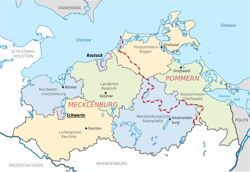
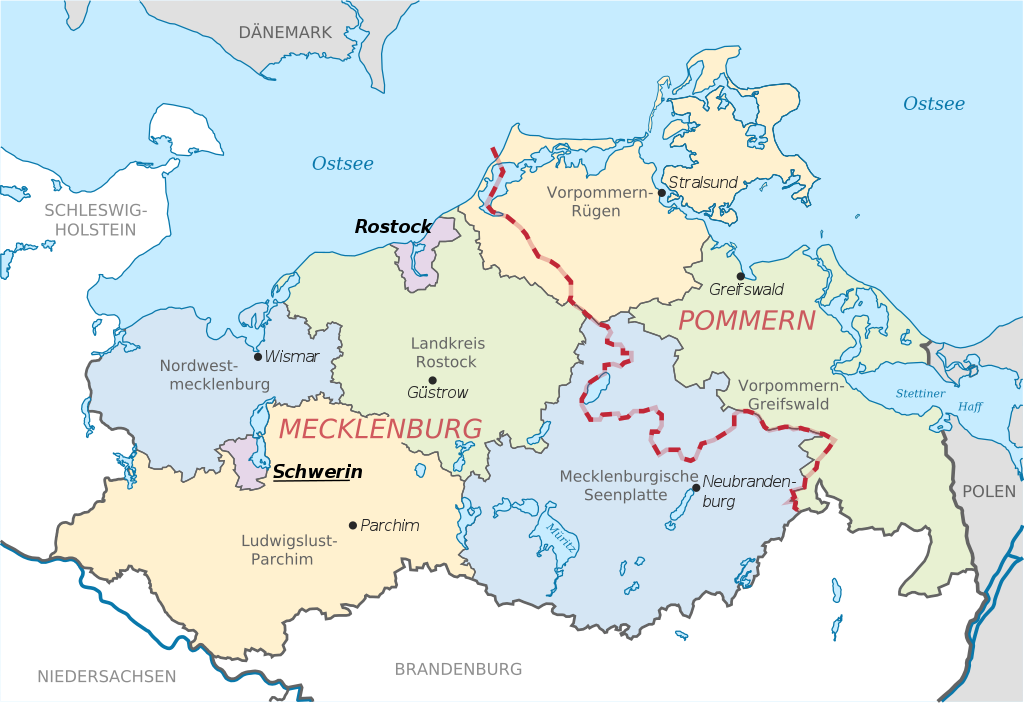
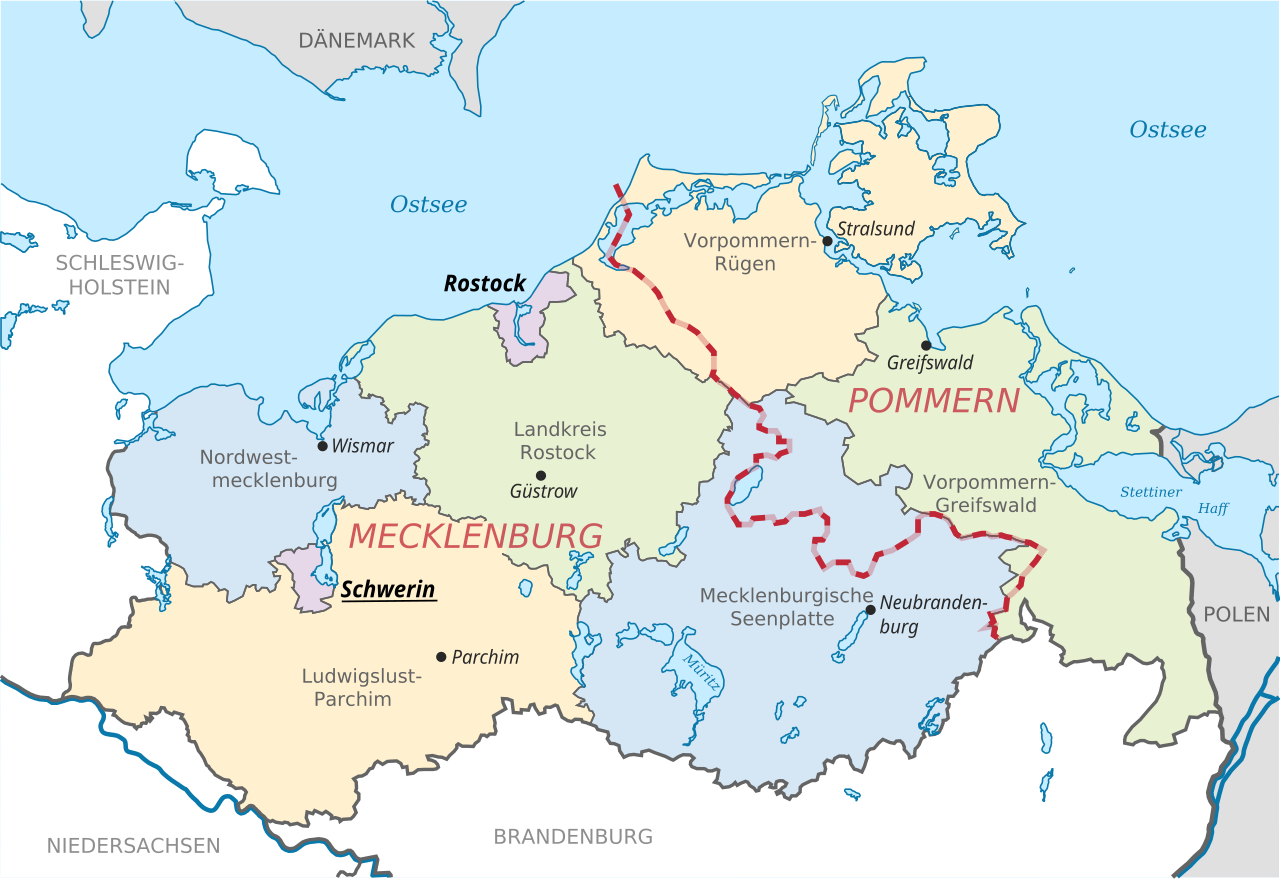
English: Locator map of counties and their seats in Mecklenburg-Vorpommern, Germany after county reorganization 2011. The red-white line indicates the former border between the state of Mecklenburg and the Prussian province of Pommerania.
Deutsch: Karte mit Lage der Landkreise und Kreisstädte in Mecklenburg-Vorpommern, Deutschland nach der Kreisgebietsreform 2011. Eingezeichnet ist auch die Grenze zwischen dem früheren Staat Mecklenburg und der preußischen Provinz Pommern. |
| दिनांक | |
| स्रोत | File:Mecklenburg-Vorpommern districts 2011 colored labeled Meck-Pomm-border.svg |
| लेखक | TUBS |
| इतर आवृत्तींस |
|


परवाना:
| This work has been released into the public domain by its author, TUBS. This applies worldwide. असे करणे काही देशांमधे कायद्यानुसार शक्य नसू शकते. असे असल्यास : |
संचिकेचा इतिहास
संचिकेची त्यावेळची आवृत्ती बघण्यासाठी त्या दिनांक/वेळेवर टिचकी द्या.
| दिनांक/वेळ | छोटे चित्र | आकार | सदस्य | प्रतिक्रीया | |
|---|---|---|---|---|---|
| सद्य | १७:२१, १६ जून २०१४ | | १,१२९ × ७७५ (७५९ कि.बा.) | Horst-schlaemma | {{Information |Description ={{en|1=Locator map of counties and their seats in Mecklenburg-Vorpommern, Germany after county reorganization 2011. The red-white line indicates the former borders of the his... |
दुवे
खालील पाने या संचिकेला जोडली आहेत:
जागतिक संचिका उपयोग
संचिकाचे इतर विकिपीडियावरील वापरः
- af.wikipedia.org वरील उपयोग
- als.wikipedia.org वरील उपयोग
- an.wikipedia.org वरील उपयोग
- ast.wikipedia.org वरील उपयोग
- ay.wikipedia.org वरील उपयोग
- az.wikipedia.org वरील उपयोग
- ba.wikipedia.org वरील उपयोग
- be-tarask.wikipedia.org वरील उपयोग
- bg.wikipedia.org वरील उपयोग
- br.wikipedia.org वरील उपयोग
- ca.wikipedia.org वरील उपयोग
- csb.wikipedia.org वरील उपयोग
- cs.wikipedia.org वरील उपयोग
- cy.wikipedia.org वरील उपयोग
- de.wikipedia.org वरील उपयोग
- de.wikivoyage.org वरील उपयोग
- dsb.wikipedia.org वरील उपयोग
- en.wikipedia.org वरील उपयोग
- eo.wikipedia.org वरील उपयोग
- es.wikipedia.org वरील उपयोग
- et.wikipedia.org वरील उपयोग
- eu.wikipedia.org वरील उपयोग
- fi.wikipedia.org वरील उपयोग
- frr.wikipedia.org वरील उपयोग
- fr.wikipedia.org वरील उपयोग
- fy.wikipedia.org वरील उपयोग
- ga.wikipedia.org वरील उपयोग
- gd.wikipedia.org वरील उपयोग
- gl.wikipedia.org वरील उपयोग
- gn.wikipedia.org वरील उपयोग
- gv.wikipedia.org वरील उपयोग
- he.wikipedia.org वरील उपयोग
- hr.wikipedia.org वरील उपयोग
- hsb.wikipedia.org वरील उपयोग
- hu.wikipedia.org वरील उपयोग
- hu.wiktionary.org वरील उपयोग
- ia.wikipedia.org वरील उपयोग
- id.wikipedia.org वरील उपयोग
- ie.wikipedia.org वरील उपयोग
या संचिकेचे अधिक वैश्विक उपयोग पहा