
चित्र:Mali map.png
यापेक्षा मोठे चित्र उपलब्ध नाही.
Mali_map.png (३५० × ३७६ पिक्सेल, संचिकेचा आकार: ११ कि.बा., MIME प्रकार: image/png)

|
This locator map image could be re-created using vector graphics as an SVG file. This has several advantages; see Commons:Media for cleanup for more information. If an SVG form of this image is available, please upload it and afterwards replace this template with
{{vector version available|new image name}}.
It is recommended to name the SVG file “Mali map.svg”—then the template Vector version available (or Vva) does not need the new image name parameter. |
सारांश
| वर्णन |
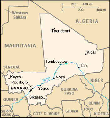
English: Map of Mali |
| दिनांक | |
| स्रोत | https://www.cia.gov/library/publications/the-world-factbook/geos/ml.html |
| लेखक | CIA |
परवाना:
| This image is a work of a Central Intelligence Agency employee, taken or made as part of that person's official duties. As a Work of the United States Government, this image or media is in the public domain in the United States.
|

|
संचिकेचा इतिहास
संचिकेची त्यावेळची आवृत्ती बघण्यासाठी त्या दिनांक/वेळेवर टिचकी द्या.
| दिनांक/वेळ | छोटे चित्र | आकार | सदस्य | प्रतिक्रीया | |
|---|---|---|---|---|---|
| सद्य | ०२:३३, ४ मार्च २००५ | | ३५० × ३७६ (११ कि.बा.) | Alfio | CIA map of Mali |
दुवे
खालील पाने या संचिकेला जोडली आहेत:
जागतिक संचिका उपयोग
संचिकाचे इतर विकिपीडियावरील वापरः
- als.wikipedia.org वरील उपयोग
- am.wikipedia.org वरील उपयोग
- ast.wikipedia.org वरील उपयोग
- bjn.wikipedia.org वरील उपयोग
- ca.wikipedia.org वरील उपयोग
- ceb.wikipedia.org वरील उपयोग
- da.wikipedia.org वरील उपयोग
- de.wikivoyage.org वरील उपयोग
- en.wikipedia.org वरील उपयोग
- es.wikipedia.org वरील उपयोग
- eu.wikipedia.org वरील उपयोग
- fa.wikipedia.org वरील उपयोग
- fi.wikipedia.org वरील उपयोग
- fo.wikipedia.org वरील उपयोग
- fr.wikipedia.org वरील उपयोग
- he.wikipedia.org वरील उपयोग
- hi.wiktionary.org वरील उपयोग
- hu.wikipedia.org वरील उपयोग
- hu.wiktionary.org वरील उपयोग
- id.wikipedia.org वरील उपयोग
- io.wikipedia.org वरील उपयोग
- ja.wikipedia.org वरील उपयोग
- jv.wikipedia.org वरील उपयोग
- ko.wikipedia.org वरील उपयोग
- nds.wikipedia.org वरील उपयोग
- nl.wikipedia.org वरील उपयोग
- no.wikipedia.org वरील उपयोग
- oc.wikipedia.org वरील उपयोग
- pl.wikipedia.org वरील उपयोग
- pt.wikipedia.org वरील उपयोग
- ro.wikipedia.org वरील उपयोग
- ru.wikipedia.org वरील उपयोग
या संचिकेचे अधिक वैश्विक उपयोग पहा