
चित्र:India states and union territories map mr.png
या झलकेचा आकार: ५३३ × ६०० पिक्सेल पिक्सेल. इतर resolutions: २१३ × २४० पिक्सेल | ४२६ × ४८० पिक्सेल | ६८२ × ७६८ पिक्सेल | ९१० × १,०२४ पिक्सेल | १,६६४ × १,८७३ पिक्सेल.
मूळ संचिका (१,६६४ × १,८७३ पिक्सेल, संचिकेचा आकार: ४४७ कि.बा., MIME प्रकार: image/png)
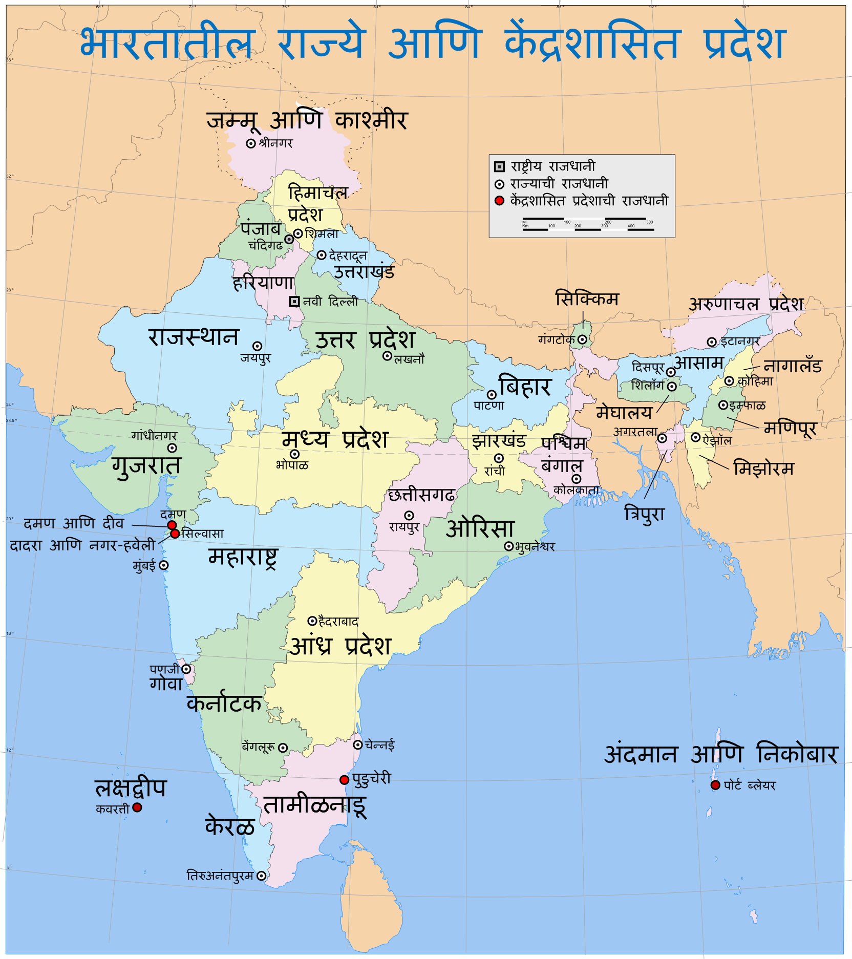
| वर्णन | Map of India, showing the states, union territories and their capitals in Marathi language. |
| दिनांक | (UTC) |
| स्रोत | |
| लेखक |
|
| This is a retouched picture, which means that it has been digitally altered from its original version. Modifications: Translated the names to Marathi. The original can be viewed here: India states and union territories map.svg:
|
I, the copyright holder of this work, hereby publish it under the following license:
ही संचिका खालील परवान्याअंतर्गत आहे - क्रीएटिव्ह कॉमन्स Attribution-Share Alike 3.0 Unported.
- तुम्ही मुक्त आहात.
- सामायिक करा – नक्कल, वितरण आणि पारेषित करण्यास
- पुर्नमिश्रीत करण्यास – काम गरजेनुसार अनुकुलीत करण्यास
- खालील अटींच्या अधिन राहून:
- रोपण – आपण योग्य क्रेडिट देणे आवश्यक आहे, परवान्यास दुवा प्रदान करणे आवश्यक आहे, आणि बदल केले गेले आहेत हे दर्शविणे आवश्यक आहे. आपण हे कोणत्याही वाजवी मार्गाने करू शकता, परंतु परवानाधारक आपल्यास किंवा आपल्या वापरास मान्यता देतो अशा कोणत्याही मार्गाने नाही.
- जसेहोते-वाटातसेच (शेअर अलाईक) – जर तुम्ही या कामात काही बदल केलात, काटछाट केलीत, किंवा भर घातली, तर असे करून बनलेले नवीन काम तुम्ही केवळ या किंवा यासारख्याच परवान्याअंतर्गत प्रसारित करू शकतात.
चढवल्याचे मुळ विवरण
This image is a derivative work of the following images:
- Image:India_states_and_union_territories_map.svg licensed with Cc-by-sa-3.0, Cc-by-sa-3.0/en
- 2006-08-07T15:41:58Z PlaneMad 1639x1852 (311672 Bytes) {{WikiProject_India_Maps |Title=India States and Union Territories map |Description=Map of India, showing the states, union territories and their capitals. |Source=. |Date=July 23 2006 |Author=[[w:user:Planemad]] |Thumbdir=C
Uploaded with derivativeFX
संचिकेचा इतिहास
संचिकेची त्यावेळची आवृत्ती बघण्यासाठी त्या दिनांक/वेळेवर टिचकी द्या.
| दिनांक/वेळ | छोटे चित्र | आकार | सदस्य | प्रतिक्रीया | |
|---|---|---|---|---|---|
| सद्य | ०१:४९, १७ डिसेंबर २००८ | | १,६६४ × १,८७३ (४४७ कि.बा.) | Abhijitsathe | {{Information |Description=Map of India, showing the states, union territories and their capitals in Marathi language. |Source=*Image:India_states_and_union_territories_map.svg |Date=2008-12-16 20:18 (UTC) |Author=*derivative work: ~~~ *[[:Image:Ind |
दुवे
खालील पाने या संचिकेला जोडली आहेत:
जागतिक संचिका उपयोग
संचिकाचे इतर विकिपीडियावरील वापरः
- kn.wikipedia.org वरील उपयोग