
चित्र:Falklandsmap.gif
यापेक्षा मोठे चित्र उपलब्ध नाही.
Falklandsmap.gif (३५० × ३७६ पिक्सेल, संचिकेचा आकार: १२ कि.बा., MIME प्रकार: image/gif)
सारांश
| वर्णन |
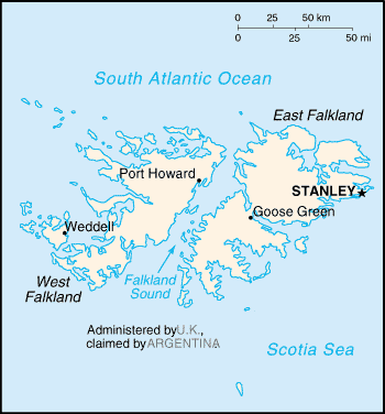
English: A map of the Falkland Islands (Islas Malvinas), showing island names and major towns. |
|||
| दिनांक | published 2004 | |||
| स्रोत | CIA, The World Factbook, 2004. | |||
| लेखक | CIA | |||
| परवानगी (या संचिकेचा पुनर्वापर करीत आहे) |
|

- first upload: March 27, 2004 - en:Wikipedia
| Camera location | | View this and other nearby images on: OpenStreetMap |
|---|
derivative works
Derivative works of this file: Weddell Island.PNG
संचिकेचा इतिहास
संचिकेची त्यावेळची आवृत्ती बघण्यासाठी त्या दिनांक/वेळेवर टिचकी द्या.
| दिनांक/वेळ | छोटे चित्र | आकार | सदस्य | प्रतिक्रीया | |
|---|---|---|---|---|---|
| सद्य | २१:४१, २५ फेब्रुवारी २००५ | | ३५० × ३७६ (१२ कि.बा.) | Nordelch | {{PD}} |
दुवे
खालील पाने या संचिकेला जोडली आहेत:
जागतिक संचिका उपयोग
संचिकाचे इतर विकिपीडियावरील वापरः
- azb.wikipedia.org वरील उपयोग
- be-tarask.wikipedia.org वरील उपयोग
- bs.wikipedia.org वरील उपयोग
- ca.wikipedia.org वरील उपयोग
- de.wikibooks.org वरील उपयोग
- en.wikibooks.org वरील उपयोग
- fi.wikipedia.org वरील उपयोग
- fr.wikipedia.org वरील उपयोग
- gl.wikipedia.org वरील उपयोग
- hr.wikipedia.org वरील उपयोग
- hr.wiktionary.org वरील उपयोग
- it.wikibooks.org वरील उपयोग
- ja.wikipedia.org वरील उपयोग
- lo.wikipedia.org वरील उपयोग
- no.wikipedia.org वरील उपयोग
- se.wikipedia.org वरील उपयोग
- th.wikipedia.org वरील उपयोग
- tr.wikipedia.org वरील उपयोग