
चित्र:East Midlands counties 2009 map.svg

Size of this PNG preview of this SVG file: ५०५ × ६०० पिक्सेल. इतर resolutions: २०२ × २४० पिक्सेल | ४०४ × ४८० पिक्सेल | ६४७ × ७६८ पिक्सेल | ८६२ × १,०२४ पिक्सेल | १,७२५ × २,०४८ पिक्सेल | १,०९९ × १,३०५ पिक्सेल.
मूळ संचिका (SVG संचिका, साधारणपणे १,०९९ × १,३०५ pixels, संचिकेचा आकार: १.६६ मे.बा.)
सारांश
| वर्णन |
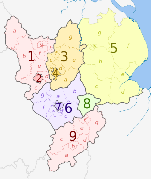
English: Map of the East Midlands region of England, showing its counties and administrative districts in 2009. The county colours are the same as those in File:English metropolitan and non-metropolitan counties 2009.svg.
See File:East Midlands counties 2021 map.svg for the counties since 1 April 2021. Equirectangular map projection on WGS 84 datum, with N/S stretched 165% Geographic limits:
|
| दिनांक | (UTC) |
| स्रोत |
This file was derived from: |
| लेखक |
|
| इतर आवृत्तींस |
|


| Map | Ceremonial county | Shire county /unitary |
Districts |
|---|---|---|---|
 |
Derbyshire | 1. Derbyshire | a) High Peak, b) Derbyshire Dales, c) South Derbyshire, d) Erewash, e) Amber Valley, f) North East Derbyshire, g) Chesterfield, h) Bolsover |
| 2. Derby U.A. | |||
| Nottinghamshire | 3. Nottinghamshire | a) Rushcliffe, b) Broxtowe, c) Ashfield, d) Gedling, e) Newark and Sherwood, f) Mansfield, g) Bassetlaw | |
| 4. Nottingham U.A. | |||
| Lincolnshire (part only) |
5. Lincolnshire | a) Lincoln, b) North Kesteven, c) South Kesteven, d) South Holland, e) Boston, f) East Lindsey, g) West Lindsey | |
| Leicestershire | 6. Leicestershire | a) Charnwood, b) Melton, c) Harborough, d) Oadby and Wigston, e) Blaby, f) Hinckley and Bosworth, g) North West Leicestershire | |
| 7. Leicester U.A. | |||
| 8. Rutland | |||
| 9. Northamptonshire | a) South Northamptonshire, b) Northampton, c) Daventry, d) Wellingborough, e) Kettering, f) Corby, g) East Northamptonshire | ||
परवाना:
ही संचिका खालील परवान्याअंतर्गत आहे - क्रीएटिव्ह कॉमन्स Attribution-Share Alike 3.0 Unported.
रोपण: Dr Greg and Nilfanion. Contains Ordnance Survey data © Crown copyright and database right 2011
- तुम्ही मुक्त आहात.
- सामायिक करा – नक्कल, वितरण आणि पारेषित करण्यास
- पुर्नमिश्रीत करण्यास – काम गरजेनुसार अनुकुलीत करण्यास
- खालील अटींच्या अधिन राहून:
- रोपण – आपण योग्य क्रेडिट देणे आवश्यक आहे, परवान्यास दुवा प्रदान करणे आवश्यक आहे, आणि बदल केले गेले आहेत हे दर्शविणे आवश्यक आहे. आपण हे कोणत्याही वाजवी मार्गाने करू शकता, परंतु परवानाधारक आपल्यास किंवा आपल्या वापरास मान्यता देतो अशा कोणत्याही मार्गाने नाही.
- जसेहोते-वाटातसेच (शेअर अलाईक) – जर तुम्ही या कामात काही बदल केलात, काटछाट केलीत, किंवा भर घातली, तर असे करून बनलेले नवीन काम तुम्ही केवळ या किंवा यासारख्याच परवान्याअंतर्गत प्रसारित करू शकतात.
चढवल्याचे मुळ विवरण
This image is a derivative work of the following images:
- File:East_Midlands_districts_2011_map.svg licensed with Cc-by-sa-3.0, GFDL
- 2011-05-01T18:55:02Z Nilfanion 1099x1305 (1687648 Bytes) == Summary == {{Information |Description=Map of the [[w:East Midlands|East Midlands]] region showing the administrative districts. Equirectangular map projection on WGS 84 datum, with N/S stretched 165% Geographic limits: *
- File:English_ceremonial_counties_2010.svg licensed with Cc-by-sa-3.0, GFDL
- 2010-11-23T16:39:55Z Nilfanion 1108x1345 (308868 Bytes) thicker lines
- 2010-11-23T16:20:19Z Nilfanion 1108x1345 (301520 Bytes) tweaks
- 2010-10-26T20:34:20Z Nilfanion 817x990 (1391832 Bytes) {{Information |Description=Map showing the [[w:ceremonial counties of England]] including the City of London, in 2010. Equirectangular map projection on WGS 84 datum, with N/S stretched 170% Geographic limits: *West: 6.75W
Uploaded with derivativeFX
संचिकेचा इतिहास
संचिकेची त्यावेळची आवृत्ती बघण्यासाठी त्या दिनांक/वेळेवर टिचकी द्या.
| दिनांक/वेळ | छोटे चित्र | आकार | सदस्य | प्रतिक्रीया | |
|---|---|---|---|---|---|
| सद्य | ०३:२४, २ मे २०१२ | | १,०९९ × १,३०५ (१.६६ मे.बा.) | Dr Greg | == {{int:filedesc}} == {{Information |Description={{en|Map of the East Midlands region of England, showing its counties and administrative districts. The county colours are the same as those in [[:File:English metropolitan and non-m... |
दुवे
खालील पाने या संचिकेला जोडली आहेत:
जागतिक संचिका उपयोग
संचिकाचे इतर विकिपीडियावरील वापरः
- ar.wikipedia.org वरील उपयोग
- de.wikivoyage.org वरील उपयोग
- en.wikipedia.org वरील उपयोग
- fa.wikipedia.org वरील उपयोग
- frr.wikipedia.org वरील उपयोग
- fr.wikipedia.org वरील उपयोग
- hr.wikipedia.org वरील उपयोग
- pl.wikipedia.org वरील उपयोग
- pnb.wikipedia.org वरील उपयोग
- pt.wikipedia.org वरील उपयोग
- th.wikipedia.org वरील उपयोग
- ur.wikipedia.org वरील उपयोग
- vi.wikipedia.org वरील उपयोग
- vls.wikipedia.org वरील उपयोग
- zh-yue.wikipedia.org वरील उपयोग