
चित्र:Cn-map.png
यापेक्षा मोठे चित्र उपलब्ध नाही.
Cn-map.png (३३० × ३५५ पिक्सेल, संचिकेचा आकार: ६ कि.बा., MIME प्रकार: image/png)

|
This locator map image could be re-created using vector graphics as an SVG file. This has several advantages; see Commons:Media for cleanup for more information. If an SVG form of this image is available, please upload it and afterwards replace this template with
{{vector version available|new image name}}.
It is recommended to name the SVG file “Cn-map.svg”—then the template Vector version available (or Vva) does not need the new image name parameter. |
सारांश
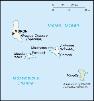
CIA map of the Comoros
परवाना:
This image is in the public domain because it contains materials that originally came from the United States Central Intelligence Agency's World Factbook.
|
 |
derivative works
Derivative works of this file:
संचिकेचा इतिहास
संचिकेची त्यावेळची आवृत्ती बघण्यासाठी त्या दिनांक/वेळेवर टिचकी द्या.
| दिनांक/वेळ | छोटे चित्र | आकार | सदस्य | प्रतिक्रीया | |
|---|---|---|---|---|---|
| सद्य | ०१:४३, १ मार्च २००५ | | ३३० × ३५५ (६ कि.बा.) | Alfio | CIA map of Comoros |
दुवे
खालील पाने या संचिकेला जोडली आहेत:
जागतिक संचिका उपयोग
संचिकाचे इतर विकिपीडियावरील वापरः
- ab.wikipedia.org वरील उपयोग
- als.wikipedia.org वरील उपयोग
- ar.wikipedia.org वरील उपयोग
- ast.wikipedia.org वरील उपयोग
- be-tarask.wikipedia.org वरील उपयोग
- be.wikipedia.org वरील उपयोग
- bjn.wikipedia.org वरील उपयोग
- bn.wikipedia.org वरील उपयोग
- bs.wikipedia.org वरील उपयोग
- ceb.wikipedia.org वरील उपयोग
- cy.wikipedia.org वरील उपयोग
- da.wikipedia.org वरील उपयोग
- de.wikinews.org वरील उपयोग
- el.wikipedia.org वरील उपयोग
- en.wikipedia.org वरील उपयोग
- es.wikipedia.org वरील उपयोग
- eu.wikipedia.org वरील उपयोग
- fa.wikipedia.org वरील उपयोग
- fi.wikipedia.org वरील उपयोग
- frr.wikipedia.org वरील उपयोग
- fr.wikipedia.org वरील उपयोग
- fr.wikinews.org वरील उपयोग
- gd.wikipedia.org वरील उपयोग
- gl.wikipedia.org वरील उपयोग
- he.wikipedia.org वरील उपयोग
- hi.wikipedia.org वरील उपयोग
- hi.wiktionary.org वरील उपयोग
- hu.wikipedia.org वरील उपयोग
- hu.wiktionary.org वरील उपयोग
- id.wikipedia.org वरील उपयोग
या संचिकेचे अधिक वैश्विक उपयोग पहा