
चित्र:Çanakkale districts.png

या झलकेचा आकार: ७७६ × ६०० पिक्सेल पिक्सेल. इतर resolutions: ३११ × २४० पिक्सेल | ६२१ × ४८० पिक्सेल | ९९४ × ७६८ पिक्सेल | १,०५६ × ८१६ पिक्सेल.
मूळ संचिका (१,०५६ × ८१६ पिक्सेल, संचिकेचा आकार: ४३ कि.बा., MIME प्रकार: image/png)
सारांश
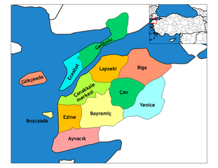
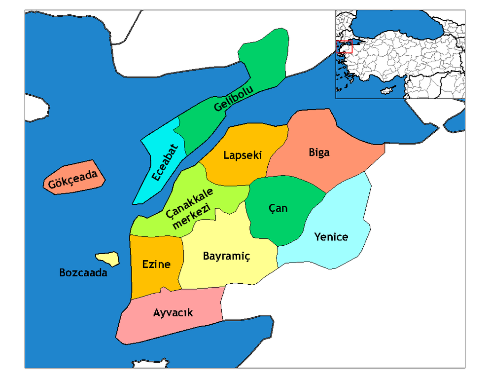
| वर्णन | Map of the districts of Canakkale province in Turkey. Created by Rarelibra 19:28, 1 December 2006 (UTC) for public domain use, using MapInfo Professional v8.5 and various mapping resources. Edited by One Homo Sapiens Corrected text where İ,Ş,ı,ğ,or ş occurs in name. Source: [statoids-com]. Increased font size and enhanced color differences among adjacent districts. |
| दिनांक | मार्च ३१, इ.स. २००७ (original upload date) |
| स्रोत | No machine-readable source provided. Own work assumed (based on copyright claims). |
| लेखक | No machine-readable author provided. Denizz~commonswiki assumed (based on copyright claims). |
परवाना:
| I, the copyright holder of this work, release this work into the public domain. This applies worldwide. असे करणे काही देशांमधे कायद्यानुसार शक्य नसू शकते. असे असल्यास : मी कोणालाही कोणत्याही कारणासाठी हे काम वापरण्याचे अधिकार कोणत्याही बंधनाशिवाय जर अशी बंधने कायद्याने बंधनकारक नसतीलतर देत आहोत. |
संचिकेचा इतिहास
संचिकेची त्यावेळची आवृत्ती बघण्यासाठी त्या दिनांक/वेळेवर टिचकी द्या.
| दिनांक/वेळ | छोटे चित्र | आकार | सदस्य | प्रतिक्रीया | |
|---|---|---|---|---|---|
| सद्य | ०९:५२, २९ डिसेंबर २००८ | | १,०५६ × ८१६ (४३ कि.बा.) | One Homo Sapiens | Corrected text where İ,Ş,ı,ğ,or ş occurs in name. Source: [statoids-com]. Increased font size and enhanced color differences among adjacent districts. |
| २१:१७, १२ एप्रिल २००७ |  | ७७६ × ६०० (११० कि.बा.) | KureCewlik81 | ||
| १२:३१, ३१ मार्च २००७ |  | १,०५६ × ८१६ (३३ कि.बा.) | Denizz~commonswiki | == Summary == Map of the districts of Canakkale province in Turkey. Created by Rarelibra 19:28, 1 December 2006 (UTC) for public domain use, using MapInfo Professional v8.5 and various mapping resources. == Licensing == {{PD-self}} <!- |
दुवे
खालील पाने या संचिकेला जोडली आहेत:
जागतिक संचिका उपयोग
संचिकाचे इतर विकिपीडियावरील वापरः
- ast.wikipedia.org वरील उपयोग
- azb.wikipedia.org वरील उपयोग
- ba.wikipedia.org वरील उपयोग
- bg.wikipedia.org वरील उपयोग
- ca.wikipedia.org वरील उपयोग
- ceb.wikipedia.org वरील उपयोग
- ce.wikipedia.org वरील उपयोग
- cs.wikipedia.org वरील उपयोग
- de.wikipedia.org वरील उपयोग
- diq.wikipedia.org वरील उपयोग
- el.wikipedia.org वरील उपयोग
- en.wikipedia.org वरील उपयोग
- Imbros
- Çanakkale Province
- User talk:Rarelibra/Maps4
- Gökçeada District
- List of populated places in Çanakkale Province
- Districts of Turkey
- Akbaş arms depot raid
- Bozcaada, Çanakkale
- Governor of Çanakkale
- Gelibolu District
- Ayvacık District, Çanakkale
- Bayramiç District
- Biga District
- Çan District
- Çanakkale District
- Eceabat District
- Ezine District
- Lapseki District
या संचिकेचे अधिक वैश्विक उपयोग पहा